|
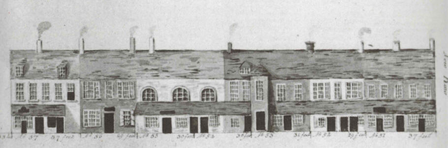
Church Street, Coleraine [South Side] from New Row towards Society Street: 1816
This drawing from the Coleraine Book of 1816, commissioned by the Irish Society, shows the houses on the south side of the street from New Row on the right of the drawing towards Society Street. Nos. 51 to 57 refer to plots of land marked on Archibald Stewart's Map of the street in 1758. The frontage of each plot is given in feet. No. 51 [at the New Row end of the drawing] was 37 feet, No. 52 was 29 feet, No. 53 was 31 feet, No. 54 was 30 feet, No. 55 was 30 feet, No. 56 was 29 feet, No. 57 was 37 feet. The houses in the drawing stop at No. 57 despite the fact that the 1758 map shows two further plots, No. 58, 33 feet and No. 59, 33 feet. The 1834 Valuation Map for this section of the street is numbered 8 to 17 from New Row to Society Street. However, Nos. 15, 16 & 17 were not included on the drawing. If you look at Nos. 8 to 17 in the 1832 Townland Valuation you will be able to see who occupied this part of the street in 1832 and the 1831 Census Returns will confirm if they actually lived there. Starting from New Row, the following persons appear to have lived here in 1832 - Robert Given, Thomas & John McMullan, Dr. Robert Huston, Samuel Caskey & Robert Nevin, William Anderson, Daniel McGregor & Stuart Norris, Dr. John Boyd, John Boylan and Samuel Brown. The houses of Boylan and Brown and the Post Office next door to Dr. Boyd's house [the last house on the left of the drawing] are not shown on the drawing. The 1832 Townland Valuation also gives the exact dimensions of each house in 1832 plus a valuation of the house and its adjoining offices. For example, the last house in the row [No. 57 on the drawing, No. 14 on the 1832 map] was occupied by Dr. John Boyd in 1832. It had a frontage of 37.5 feet, was 22.0 feet deep and 32.0 feet high (suggesting 3 storeys) and was valued at £21.00. This house had been the old rectory of St. Patrick's Church across the street. In 1829 a new rectory was built on the Mountsandel Road. By 1859 the house had been taken over by Daniel Taylor. He did not live there. There were now two shops in the building, one was still to be let and the other was occupied by John Huey (Meal & Flour Merchant). Robert Given had a house and shop at the the other end of the row, adjoining New Row. As to the houses in between the Given and Boyd houses, it is possible to match the 1832 names to the 1816 houses reasonably well if you compare the frontages given in the 1832 Valuation with those given in the drawing above, and the 1758 map. However, note that there was considerable rebuilding in this part of the street before and after 1859. However [No. 52 on the 1758 map, No. 9 on the 1832 map] changed little during the nineteenth and first half of the twentieth century, becoming known locally as McLaughlin's public house and McGrath's butcher's shop. Also No. 59 on the 1758 map and No. 17 on the 1832 map [but not shown on the drawing] also changed little until the 1930s, becoming known locally as Currie's public house and Blair's greengrocer's shop. Photographs of these buildings can be seen in the photographs of the street in the early 1900s. |