|
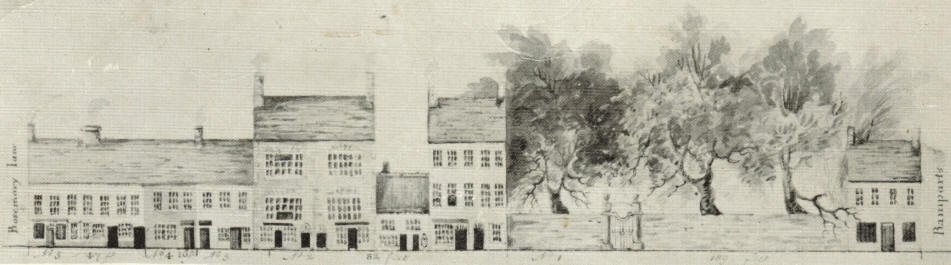
Church Street, Coleraine [North Side] from Park Street (Rosemary Lane) to Kingsgate Street (Ramparts): 1816
This drawing from the Coleraine Book of 1816, commissioned by the Irish Society, shows the houses on the north side (or Church side) of the street from Rosemary Lane (now Park Street) to the Ramparts (now the beginning of Kingsgate Street). Nos. 1 to 5 refer to plots of land marked on Archibald Stewart's Map of the street in 1758. The frontage of each plot is given in feet. No. 1 [at the Ramparts end of the drawing]was 189 feet, No. 2 was 82 feet, No. 3 no frontage* is given on the drawing, No. 4 was 16 feet and No. 5 was 47 feet. The 1834 Valuation Map for this section of the street is numbered 18 to 27 from the Ramparts to Rosemary Lane. If you look at Nos. 18 to 27 in the 1832 Townland Valuation you will be able to see who occupied this part of the street in 1832 and the 1831 Census Returns will confirm if they actually lived there. Starting from the two storey house beside the ramparts, the following persons appear to have lived here in 1832 - Sam King, then the church, then Robert McWilliams, Eneas McAllister, Robert Turbitt, Robert Thompson, James Curry, Robert Acheson, Miss Robb, and John Knox at the corner with Rosemary Lane. Because of the number of doors shown in the drawing, matching persons to particular houses in the drawing is not always easy. I think that some of the doors are separate entrances to shops within houses. Furthermore it looks as if there had been some structural changes in some of the buildings between 1816 and 1832. The 1832 Townland Valuation also gives the exact dimensions of each house in 1832 plus a valuation of the house and its adjoining offices. For example, the house to the left of the church was occupied by Robert McWilliams (Publican) in 1832, Its dimensions in 1832 were 23.5 feet of a frontage, 27.5 deep and 24.5 feet high (which suggests 3 storeys, confirmed by the drawing) and its valuation was £14.00. By 1859 it was occupied by John Lusk (Corn & Flour Merchant) and its dimensions were 24.0 feet of a frontage, 32.0 feet deep and 3 storeys with an increased valuation of £35.00, suggesting considerable rebuilding and refurbishment of the house. Another example is the little house, on plot No. 2 on the drawing, sandwiched between McWilliams' house and Turbitt's house. By 1832 this house had become three storeys with a frontage of 22.0 feet and a depth of 31.9 feet and was occupied by an Eneas McAllister (Saddler & Harness Maker). The 1859 dimensions given were 21.0 feet of frontage, 32.0 feet deep and 3 storeys high. The house to the left of McAllister was the three storey house occupied by Robert Turbitt and Robert Thompson (Linen Merchant, Bleacher & Haberdasher). Thompson's part of the house (on the left of the building) had a frontage of 22.0 feet, was 32.0 feet deep and 27.5 feet high and was valued at £20.30. By 1859 Thompson had gone to the corner of the Diamond and Church Street and his house was now occupied by John McCandless (Grocer & Post Office). The 1859 dimensions for the house were the same as those for 1832 and the valuation was £22.00. So, little change had taken place. The remainder of the houses in this part of the street, as far as Rosemary Lane, were all 2 storeys in 1816, 1832 and 1859. * The frontage given on the 1758 map for No. 3 is 44 feet. However this figure is not consistent with the frontages given in both the 1832 and 1859 valuations. The total figure for frontages in this part of the street is approximately 170 feet in both the 1832 and 1859 valuations. The total figure for 1758 is 189 feet, a discrepancy of 17 feet.. |